Additional information
| Weight | 1.2 lbs |
|---|---|
| Dimensions | 24 × 4.25 × 4.25 in |
 October (Giclee)1 × $110.00
$36.00
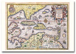
Map by Theodore De Bry, 1594
Queen Elizabeth I granted Sir Walter Raleigh a charter enabling him to settle an English colony in America in 1584. The colonist established their headquarters on Roanoke Island on the Outer Banks of North Carolina, naming the region Virginia. John White was sent to draw and record the geography, natives, and natural history of the area. His map was the first printed English record of Raleigh’s attempts to plant a colony in the New World and the first to include the name Chesepiooc Sinus.
28″ x 20″
| Weight | 1.2 lbs |
|---|---|
| Dimensions | 24 × 4.25 × 4.25 in |
 Add to cart
$100.00
Add to cart
$100.00
 Add to cart
$110.00
Add to cart
$110.00